[Guest blog post: Sayon Dutta is an emergency medicine physician with prior training in aerospace engineering and currently is completing a research fellowship in applied technologies. His research includes GIS and mobile technologies in humanitarian emergencies and the utilization of medical informatics to improve patient care in the Emergency Department. He is a key contributor the the HSI simulation applied technology module. Jennifer Chan is an associate faculty member at Harvard Humanitarian Initiative (HHI), an emergency medicine physician and public health provider. She is a technical consultant and field researcher for humanitarian NGOs with the Program on Humanitarian Effectiveness. She continues to incorporate applied technologies in collaborative projects and leads the Humanitarian Disaster Simulation Exercise applied technology module.]
In April 2010, 90 students and a team of 9 volunteers participated in a 3-day simulation of the humanitarian emergency in Chad/Darfur. Prior to the simulation students learned about geospatial and mobile technologies in humanitarian response. Ushahidi was presented as an example of crowdsourcing and crisis mapping.
During the simulation staged in a US state park, students acted as humanitarian workers and became end-users feeding crisis information to the Ushahidi-HSI platform. While learning key skills in program planning, security events, and field epidemiology, these students participated in crowdsourcing crisis information during a simulated emergency.
This was the second year incorporating Ushahidi into the Humanitarian Studies Initiative Simulation program. Improvements in 1) didactics and preparation 2) Ushahidi platform technology 3) satellite communications and 4) volunteer capacity resulted in a successful educational experience for future humanitarian responders.
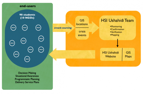 Real-time information was transmitted via SMS to Frontline SMS and Ushahidi-HSI. Information was also mapped using open-source GIS programs as part of the applied technology learning objectives. The information was fed back to students in real- time and at scheduled mock UN Headquarter meetings.
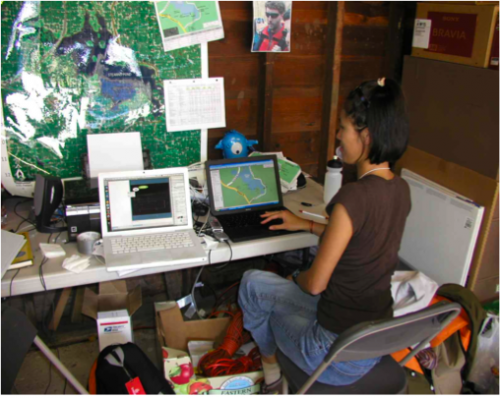
 Human and technical capacity challenged the timely information feedback loop to end-users. The volunteer team managed large volumes of Ushahidi information while also GIS mapping. This often delayed communicating information back to NGO teams. The Frontline SMS system also stalled when batched messages were sent to all NGO teams.
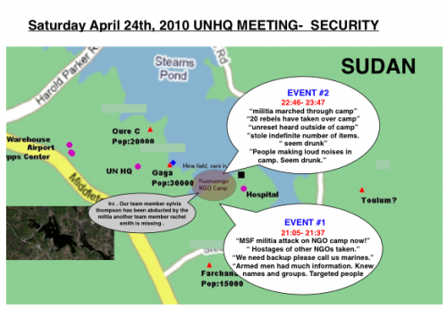 Mapping events on Ushahidi during the simulation was challenging as the administrative fields were in lat/long units while the student SMS texted coordinates in degrees/min/min-seconds. Volunteers needed to convert the units independently prior to entering it into the report page. This was time consuming and prone to error. The field was not used and sites were mapped by proxy by individual volunteers.
During the simulation, geo-coordinates of key locations (e.g, refugee camps) should be accurately mapped using common units or an embedded conversion system. Creating an internal unit conversion system for geo-coordinates on Ushahidi may improve the use of this new function. Most crisis events were “proxy” tagged by end users. Locations instead of exact coordinates were most commonly used. If the Ushahidi platform could link “location” with it’s previously confirmed geo-coordinate this would increase the efficiency of data processing and minimize “noise” improving interpretation of Ushahidi maps.
Frontline SMS and Ushahidi information was also used to create more detailed maps to aid in NGO team decision making, program planning and service deliverables.

2010 SIM activities
Throughout the simulation students SMS texted crisis events and geospatial coordinates (e.g., refugee camps) to the HSI-Ushahidi platform. Ushahidi became the repository for GIS and crisis information. A volunteer team received, monitored,confirmed, verified, and mapped information. Real-time information was transmitted via SMS to Frontline SMS and Ushahidi-HSI. Information was also mapped using open-source GIS programs as part of the applied technology learning objectives. The information was fed back to students in real- time and at scheduled mock UN Headquarter meetings.
Implementation - Technical
Harold Parker State Park has cell phone access but no internet access. One major improvement was the incorporation of satellite technology. This enabled the applied technology team to access the internet to confirm, verify, and map Ushahidi data. This on-site, real time feedback to students was not available during the 2009 Simulation. With the assistance of Ushahidi technical staff the 2010 HSI Ushahidi Platform was improved with new fields for geospatial coordinates and statistics. Similar categories of reportable instances (e.g., camp locations, deaths, land-mines, militia movements, disease, and mass graves) were used again.Implementation - Human Capacity
Another improvement during the 2010 Simulation was the creation of an applied technology team of volunteers. Under the guidance of a faculty member, the team was responsible for pre-simulation preparation and all GIS and Ushahidi activities. The nine person team included individuals with advanced skills in satellite technology, GPS skills, recent experience with Ushahidi Haiti, and other with new interests in ICT. The team outfitted each NGO team with GPS units, information cards, and supported students “in the field”. They also managed large volumes of information, processing the data and transforming it to traditional maps while updating the Ushahidi-HSI platform. The team also created “security breaches” gaming the system to teach students about the fragility of ICT in emergency and insecure environments.Informing End Users
Students or “end-users” were either introduced to Ushahidi in a classroom session or during the first meeting of the simulation. Cards were distributed at the beginning of the simulation to all students with instructions on how to communicate crisis events to Ushahidi.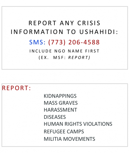
Crowdsourcing
Within minutes of the simulation, Ushahidi began receiving messages. A total of 287 SMS text messages came into Frontline SMS. All messages were monitored. Information that could be verified was subsequently mapped resulting in 41 mapped reports on the Ushahidi website. Messages were received every few minutes and during a simulated militia raid security related messages were received multiple times a minute.
Frontline SMS/Ushahidi Interface
Not all Frontline SMS messages were forwarded to Ushahidi, and transferred texts were frequently delayed. This hindered the team’s ability to process information. The compressed activities of the simulation may have contributed to this challenge which may not occur in a real humanitarian settings. Frontline SMS was also used for internal communication between the volunteers. Although it only comprised 12% of all received messages, this created “noise” that needed to be screened and omitted.Monitoring and Creating Reports
As experienced in the 2009 simulation, there were many duplicate messages of similar events. This provided a means for verification, but also congested the system. The temporary solution was to have the team visually screen all Ushahidi messages and transform the information into reports when appropriate. This required human capacity and resources during the simulation, but the learning curve for new members was fast. Swift River was not used this year, but may have the potential to decrease this demand and increase accuracy in future simulations.Verification
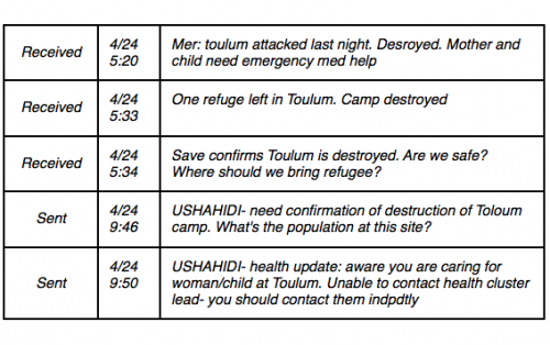
In order to maintain the educational goals the decision was made to view crowdsourced information and create reports which were a reflection of at least 2-3 similar messages from distinct end-users. Real-time decision-making was necessary to prompt the groups to verify information in order to validate an event and create a report. This process also indirectly educated students about the value of triangulated and verified information for decision-making. During the simulation, militia raids destroyed the “Toulum” refugee camp. The following messages reflect the series of texts, followed by prompting NGOs to confirm the event. It also is an example of how the the applied tech team must determine how to manage unanticipated events which is more reflective of true humanitarian settings. Human and technical capacity challenged the timely information feedback loop to end-users. The volunteer team managed large volumes of Ushahidi information while also GIS mapping. This often delayed communicating information back to NGO teams. The Frontline SMS system also stalled when batched messages were sent to all NGO teams.
Security/Mapping
Security was a major theme during the simulation, and the NGO camp was raided. In one hour, Ushahidi received 58 text messages about the crisis event. Ushahidi had “technical difficulties” (intentionally) to educate students about the fragility of technology during emergencies. For learning purposes their information was presented at the following UN meeting reflecting how crowdsourced information could be triangulated. Mapping events on Ushahidi during the simulation was challenging as the administrative fields were in lat/long units while the student SMS texted coordinates in degrees/min/min-seconds. Volunteers needed to convert the units independently prior to entering it into the report page. This was time consuming and prone to error. The field was not used and sites were mapped by proxy by individual volunteers.
During the simulation, geo-coordinates of key locations (e.g, refugee camps) should be accurately mapped using common units or an embedded conversion system. Creating an internal unit conversion system for geo-coordinates on Ushahidi may improve the use of this new function. Most crisis events were “proxy” tagged by end users. Locations instead of exact coordinates were most commonly used. If the Ushahidi platform could link “location” with it’s previously confirmed geo-coordinate this would increase the efficiency of data processing and minimize “noise” improving interpretation of Ushahidi maps.
Frontline SMS and Ushahidi information was also used to create more detailed maps to aid in NGO team decision making, program planning and service deliverables.

Presenting Ushahidi Findings
The greatest limitation of the Ushahidi web platform was presenting findings back to the end users/students in real time. In order to simulate the challenging humanitarian environment, student access to computers was not ubiquitous and internet access was unavailable. As a work around to this true to life limitation, printed screen shots of the Ushahidi website were presented at the meetings. To improve the students’ understanding of Ushahidi outputs, future simulations could incorporate:- Use large screen monitor at the group meetings to show the HSI-Ushahidi website to students and allow students to interface with the website at that time.
- Encourage students with internet access on their smart phones to view Ushahidi online during the simulations.
- A Ushahidi skill-station prior to the simulation. Students would have more time to learn the web interface so they may view the real time output more efficiently during the stressful simulation.
- When viewing the main webpage the site would stall for prolonged periods of time. Reloading the site or clicking on another tab and returning to the main page would often fix the problem.
- We were also unable to set the background timeline to the current 2010 simulation, excluding the data from 2009. With a few clicks this was possible, but we anticipate students with multiple demands would best learn from more a more controlled interface.
- Unique to the HSI simulation, a broad range of events occurred in a compressed area and time period. A more granular timeline (by the hour) would have been more useful, but may not be reflective of other real events.
Student/End User Feedback
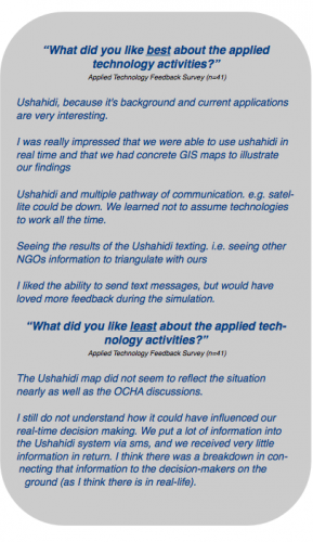
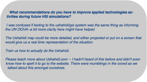
Overall feedback from the HSI students was positive and many students requested more didactic teaching and simulation feedback. 44% of students believe that Ushahidi somewhat influenced their learning during the simulation, and 27% believe that Ushahidi frequently or “always” influenced their learning.