During my first few weeks in Liberia, I found myself at the mercy of my driver. The lack of street signs and numbered addresses meant that finding an office inevitably involved stopping to ask a woman selling bananas, or going up and down nearby streets until we’d eyed each nook and cranny of the concrete honeycomb. This isn’t how two mapping consultants go about their business, John and I thought; we had the power to do something, however small, about the disorder of Liberia’s capital. So we set out on in John’s surfboard-adorned jeep with GPS unit in hand.
Our initial goal was simple: to map as many NGOs we came across in that one day. We could start a map with this information and then hand it over to the public for crowdsourced locations of interest. We started with NGOs because this is the sector to which most of our local partners belong, and because we thought putting them on the map might – just might - begin to address the NGO community’s lack of consistent coordination and communication.
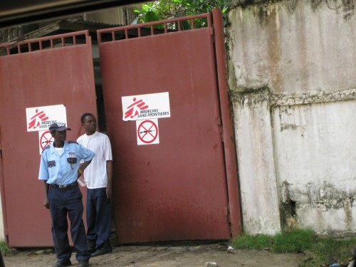
Our mapping day was sunny with no clouds – a rare occurrence during the rainy season. On the console of the jeep was our eTrex Garmin GPS unit, in my lap an open notebook for recording the name of each location (in GPS terms “waypoint”) and, in the crease of the notebook, a small digital camera for snapping the entrance to each organization. We were admittedly undercover on this mapping mission; while none of the NGOs we planned to geo-locate were secretive about their post or mission, there were security guards manning each gate and thus any suspicious behavior (like flashing fancy gadgets, copying down coordinates, taking photos out of vehicles) would likely be questioned – that is, if we were stationary long enough.
[caption id="attachment_2525" align="aligncenter" width="500" caption="Guarded NGO gates"] [/caption]
So John was the driver and I the notation officer – when we saw an NGO signboard approaching, he would slow down to the side of the road; with one hand I would start copying down the name, with the other I lifted the camera and glanced through for a quick snap of the building and, as soon as the camera was down (which was usually just as we were cruising up to the entrance), I would click the GPS unit to record the waypoint, John would read aloud the coordinates as I copied them down in my notebook (for good measure), and finally he would speed up and back onto the main road. Each drive-by took roughly thirty seconds, and on that one day we were able to collect the locations of 55 different NGOs, mostly international, in the greater Monrovia area. This, amazingly, does not encompass all of the INGOs in town, not to mention the hundreds of local NGOs we have yet to map.
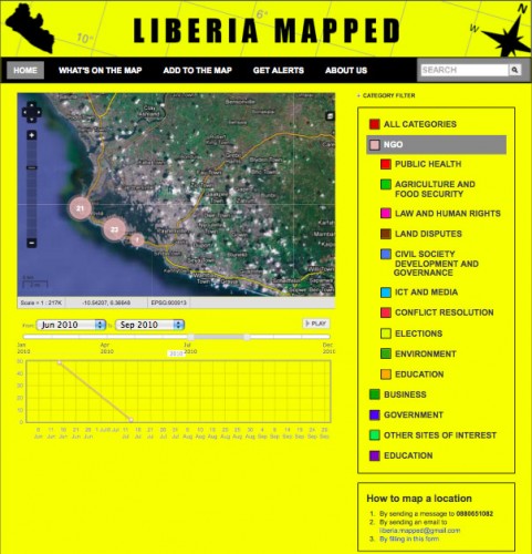
Back at the office, we had to decide how best to display these organizations on the map. We realized that if we aimed not only to locate organizations but also to improve the likelihood of communication between them, points on a map alone wouldn’t do the job; the dots, as we originally envisioned them, would simply answer the question I constantly faced upon arrival – “where in the world is NGO xyz?” Greater information sharing, we decided, might be better facilitated by providing a variety of data on each organization - such as each NGO’s mission, types of programs, and links to any available online information. In addition, we created ten general categories under which most of the NGOs' activities fell, as a way of clustering organizations around programmatic overlap and individuation. We also made customized changes to the Ushahidi instance’s default tabs; for example, “reports” became “places on the map”, “submit an incident” became “add to the map."
[caption id="attachment_2524" align="aligncenter" width="481" caption="Liberia Mapped"]
 [/caption]
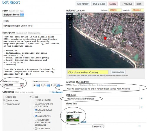
It didn’t take long for us to realize what template we were trying to replicate: the Yellow Pages. A Liberian Yellow Pages, however, needs some additional features: nuanced addresses (such as “the alley just behind the Carter Center in Mamba Point, Monrovia”), photographs such as the ones we took to distinguish one steel gate from another, and the date of the submission to determine how recently the information was added (and thus the likelihood the NGO is operational and in said location). Web links to an organization's website or related articles can provide users with additional info without navigating away from the page.
[caption id="attachment_2523" align="aligncenter" width="500" caption="Submitting information to Liberia Mapped"]
 [/caption]
For this budding Liberian directory, what we're calling Liberia Mapped, to become a viable one-stop shop for everything from development initiatives to best restaurants, we need the public to populate it. We’ve started in the capital city only because that is where we are able to easily geo-locate or verify submissions, but we welcome any sites of interest not already included. If a category does not yet exist, suggest one! If there’s a report about your NGO or business and you want to change it, let us know! Liberia Mapped is to encourage information sharing in a place where, for too long, the lack of an easily accessible and centralized data source has been the perennial excuse for poor communication, transparency and accountability.
 [/caption]
So John was the driver and I the notation officer – when we saw an NGO signboard approaching, he would slow down to the side of the road; with one hand I would start copying down the name, with the other I lifted the camera and glanced through for a quick snap of the building and, as soon as the camera was down (which was usually just as we were cruising up to the entrance), I would click the GPS unit to record the waypoint, John would read aloud the coordinates as I copied them down in my notebook (for good measure), and finally he would speed up and back onto the main road. Each drive-by took roughly thirty seconds, and on that one day we were able to collect the locations of 55 different NGOs, mostly international, in the greater Monrovia area. This, amazingly, does not encompass all of the INGOs in town, not to mention the hundreds of local NGOs we have yet to map.
Back at the office, we had to decide how best to display these organizations on the map. We realized that if we aimed not only to locate organizations but also to improve the likelihood of communication between them, points on a map alone wouldn’t do the job; the dots, as we originally envisioned them, would simply answer the question I constantly faced upon arrival – “where in the world is NGO xyz?” Greater information sharing, we decided, might be better facilitated by providing a variety of data on each organization - such as each NGO’s mission, types of programs, and links to any available online information. In addition, we created ten general categories under which most of the NGOs' activities fell, as a way of clustering organizations around programmatic overlap and individuation. We also made customized changes to the Ushahidi instance’s default tabs; for example, “reports” became “places on the map”, “submit an incident” became “add to the map."
[caption id="attachment_2524" align="aligncenter" width="481" caption="Liberia Mapped"]
 [/caption]
It didn’t take long for us to realize what template we were trying to replicate: the Yellow Pages. A Liberian Yellow Pages, however, needs some additional features: nuanced addresses (such as “the alley just behind the Carter Center in Mamba Point, Monrovia”), photographs such as the ones we took to distinguish one steel gate from another, and the date of the submission to determine how recently the information was added (and thus the likelihood the NGO is operational and in said location). Web links to an organization's website or related articles can provide users with additional info without navigating away from the page.
[caption id="attachment_2523" align="aligncenter" width="500" caption="Submitting information to Liberia Mapped"]
 [/caption]
For this budding Liberian directory, what we're calling Liberia Mapped, to become a viable one-stop shop for everything from development initiatives to best restaurants, we need the public to populate it. We’ve started in the capital city only because that is where we are able to easily geo-locate or verify submissions, but we welcome any sites of interest not already included. If a category does not yet exist, suggest one! If there’s a report about your NGO or business and you want to change it, let us know! Liberia Mapped is to encourage information sharing in a place where, for too long, the lack of an easily accessible and centralized data source has been the perennial excuse for poor communication, transparency and accountability.