Creating an ecosystem of early warning and response actors in Liberia necessitates involvement from various levels of that system – local civil society organizations, international NGOs, the UN, government ministries, the national police and armed forces. Our team on the ground has spent much of the first couple months meeting with international NGOs (of which there are more than 70 based in Monrovia alone) and the UN – key players in this multi-layered approach to conflict prevention and intervention. Many of these potential partners were eager to begin mapping – but with several of them, we hit the same wall: our maps, they said, didn’t have enough information. Well, not “our” maps, but rather the base layer maps used here in Liberia for Ushahidi instances – Google Maps. And Google is certainly not at fault for having sparse Liberia maps; when geospatial information is in the public domain, it’s only a matter of time until it’s on Google’s many map layers. It was in the public domain where we hit our wall – Liberia’s census data (containing detailed information about roads, towns and villages, county and district boundaries) was not, despite its public nature, freely available without license or restriction. There was no way around it; we were going to have to go to LISGIS.
LISGIS is the Liberia Institute of Statistics and Geo-Information Services, and it is notorious for keeping its data on a short leash. John (our team’s tech support manager extraordinaire) tried getting in touch with the Institute: a personal visit, an official letter – all to no avail. Meanwhile the UN Mission in Liberia, the Norwegian Refugee Council and others were waiting to use Ushahidi – but without county and district boundaries displayed on Ushahidi’s maps, there was little our team could offer.
What was in fact the most challenging aspect of this data-chase was that we already had the LISGIS data; through one of his contacts at an NGO, John was able to view purchased LISGIS shapefiles in all their glory – one map after another of detailed boundary lines and villages with populations as few as five. But these shapefiles were licensed to one particular organization for internal use, and therefore just out of reach (picture John and I at our desks, grinding teeth and biting nails).
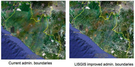
During a meeting with the Ministry of Internal Affairs’ Peacebuilding Office, we mentioned this data deadlock; the Director of the Peacebuilding Office (PBO), one of the most connected men in Monrovia, casually offered to accompany us on our next trip to LISGIS. The head of the Institute, he said, was a personal friend. And here the tides began to turn. In one visit, the PBO’s Director arranged a verbal agreement with LISGIS to release county and district boundaries, cities and villages, plus main and arterial roads for Google’s use; all that remained was for John and myself to get it down on paper. And Google? Our contacts at HQ were more than happy to post the census data on their maps as soon as we sent them signed permission. I will abbreviate the course of events that followed, however I would be doing you an injustice if I did not at least summarize the run-around that ensued – it is, after all, an integral part of data collection in Liberia:
 [/caption]
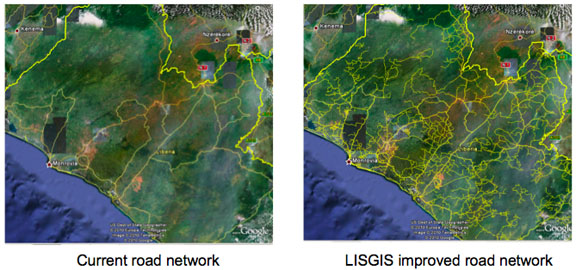
[caption id="attachment_2727" align="aligncenter" width="576" caption="Before and After: Main and Arterial Roads"]
 [/caption]
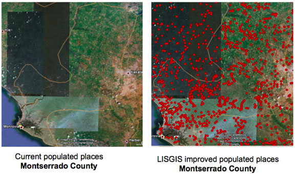
[caption id="attachment_2728" align="aligncenter" width="576" caption="Before and After: Cities and Villages"]
 [/caption]
If you would like to see the shapefiles for yourself, check out this link on John’s site: http://johnetherton.com/file-share/Liberia/Census-Data/2008/
- Personally delivered document on PBO letterhead to LISGIS for the Director’s signature
- Hastily walked out of the office with signed permission in-hand. Wait – he put the wrong date
- Back to the office. Director crossed out the date, initialed, corrected it. Quickly again out the door to scan the document off to Google. Done!
- Not quite. Google writes: the document is not on LISGIS letterhead, and the Director’s listed email is a Yahoo address rather than an official LISGIS address (Liberians do have a fondness for elaborate Yahoo addresses)
- John inquires about the official email address: LISGIS does not have one. Fine, Google understands, how about just a signature on letterhead, minus the Yahoo?
- Got it. Back to LISGIS. Up the stairs, into the office – the entire staff is on retreat. For the week. In a faraway town
- The next week: up the stairs, into LISGIS, yes hello again I know I’m truly trying my luck but my bossman says I have to get this on your letterhead. Okay, said the secretary – but not on that thing (I’ve brought a USB stick with the original document). I don’t ask why – sure, would you like to retrieve the document from my email? They would rather rewrite the entire document based on a hard copy. I offered to type it – no, no problem we can do it
- I waited in the lobby. The secretary brought me a copy – there are some typos. She tries again. Another copy – a few remaining mistakes. Once more. An hour later, a pristine rewrite. She went for the signature – can we get two copies, I asked? I’m bit my lip, I had pushed too far, there was no way we could get away with this now. I waited some more
- Secretary emerged, signed documents in hand. On letterhead. I bolted out of the door, scanned, copied, FedExed to Google, nearly framed the copies and built a mantle on which to admire them within the same hour. Really. Done.
 [/caption]
[caption id="attachment_2727" align="aligncenter" width="576" caption="Before and After: Main and Arterial Roads"]
 [/caption]
[caption id="attachment_2728" align="aligncenter" width="576" caption="Before and After: Cities and Villages"]
 [/caption]
If you would like to see the shapefiles for yourself, check out this link on John’s site: http://johnetherton.com/file-share/Liberia/Census-Data/2008/