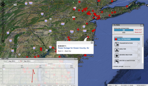
I was gearing up for a trial run of this satellite imagery analysis project for Somalia when my colleague Aaron Huslage decided to launch the Irene Recovery Map. He reached out to various communities for help and many groups joined him to suppor this efforts. In alphabetical order: CrisisCommons, CrisisMappers, Geeks without Bounds, GIS Corps, Humanity Road, Info4Disasters, Standby Volunteer Task Force, Tethr and Ushahidi. As usual, we organized ourselves on Skype and eventually followed a model similar to that of the Standby Volunteer Task Force.
 The purpose of this blog post is to share some early lessons learned on this project. These come directly from my involvement in the project and hence reflect the actions I took over the past 48 hours. Please do add your own lessons learned and observations in the comments section below if you were involved in the Recovery Map. I'd like to categorize these lessons into two areas: Strategy and Technology. Since I personally focused more on the strategy side of the project, I'll invite my technology colleagues to share their lessons on the tech side in the comments section.
On the strategy side, one important point worth noting is the URL or domain name chosen for the deployment. If the domain name is tied to an existing company or organization, this can make it more difficult to partner with another organization and in particular a media company. The URL necessarily brands the site so the more neutral the title the better. This is why we switched to Irene Recovery Map.
You'll want to put together a media and outreach strategy earlier rather than later. So recruit colleagues who have strong links with the media and ask them to reach out to their contacts to help publicize the map. Create a Google Doc where these colleagues can draft a short introductory text that they can each use when reaching out. This keeps the messaging consistent. Obviously, make as much use of social media as possible to get your message out.
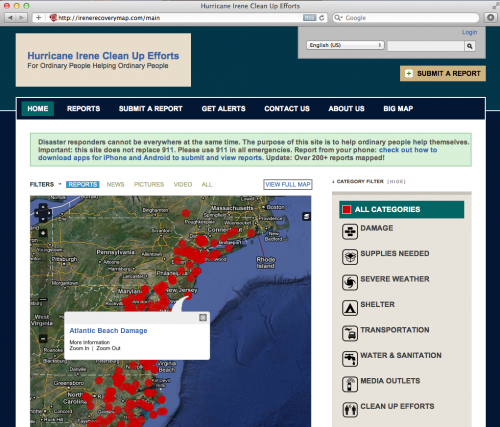
 Another piece of advice on the strategy side is to really think through the purpose of the live map and to find a niche. A generic or vague description is simply not compelling. Think through the comparative advantage that you and your partners have in launching a live map. We didn't have any partnerships with official responders, for example. So I decided to "rebrand" our efforts and added a new tag line: "For Ordinary People Helping Ordinary People" and added a "Clean Up Efforts" category. In addition, I added a succinct rationale for the project in the text box above the map: "Disaster responders cannot be everywhere at the same time. The purpose of this site is to help ordinary people help themselves."
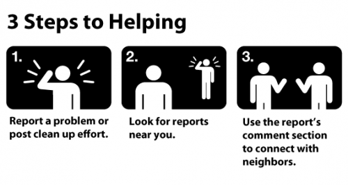
On a related note, provide a very simple way for people to understand how they can use the map. We borrowed the graphic below from an earlier deployment (Snowmageddon NY) and added it to the Recovery Map. The point here is not to assume that new users of the map will necessarily know how to leverage the information displayed. Don't make them have to figure it out. Make it easy and intuitive.
 Next, promote the use of smart phone apps as early as possible in the launch of your live map. Publicize these on the home page and provide the necessary links to download the apps as well as a Google Doc like this one on how to make best use of these apps when reporting information to the map.
Finally, make sure you have an "About Us" section. If would-be users have no idea who is behind the initiative, they are far more likely to hesitate in using the site. Be sure to list all the organizations in your broad coalition of partners working on the initiative. This not only recognizes individuals who are working around the clock, it also helps to increase the credibility and trustworthiness of the project.
On the technology side, Ushahidi needs to make an embed map function directly available on every Ushahidi deployment. This is important because having other websites embed the map (particularly media websites) helps to spread the word and extend the credibility of the efforts. Ushahidi also needs to make a wide range of standard icons directly available from the backend of the platform. The shape of the map on the home page should also be modifiable from the backend. In terms of the smart phone apps, Ushahidi should have a feature that displays the download links directly on the home page.
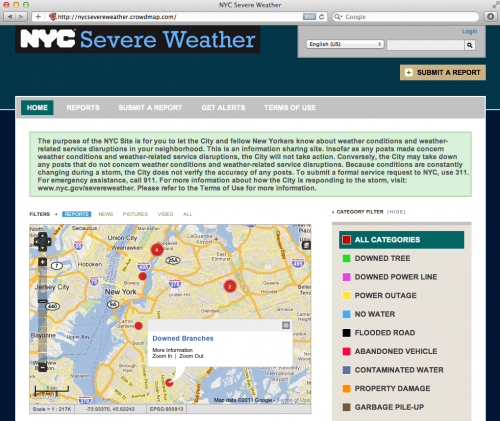
 There were at least 3 other live maps (powered by Ushahidi) that were launched in response to Hurricane Irene. One of these is particularly noteworthy given that it was launched by the Office of Emergency Management of New York City. The NYC Severe Weather Map above is thus definitely a first in this respect. We've worked with the NYC team over the past few days to make modifications to their Crowdmap and look forward the team's feedback after the recovery efforts.
Update: We've connected the Office of Emergency Management with Mobile Commons who have set up an SMS number for the map which WNYC and The New York Times are starting to promote. Text IRENE to 877877.
 The purpose of this blog post is to share some early lessons learned on this project. These come directly from my involvement in the project and hence reflect the actions I took over the past 48 hours. Please do add your own lessons learned and observations in the comments section below if you were involved in the Recovery Map. I'd like to categorize these lessons into two areas: Strategy and Technology. Since I personally focused more on the strategy side of the project, I'll invite my technology colleagues to share their lessons on the tech side in the comments section.
On the strategy side, one important point worth noting is the URL or domain name chosen for the deployment. If the domain name is tied to an existing company or organization, this can make it more difficult to partner with another organization and in particular a media company. The URL necessarily brands the site so the more neutral the title the better. This is why we switched to Irene Recovery Map.
You'll want to put together a media and outreach strategy earlier rather than later. So recruit colleagues who have strong links with the media and ask them to reach out to their contacts to help publicize the map. Create a Google Doc where these colleagues can draft a short introductory text that they can each use when reaching out. This keeps the messaging consistent. Obviously, make as much use of social media as possible to get your message out.
 Another piece of advice on the strategy side is to really think through the purpose of the live map and to find a niche. A generic or vague description is simply not compelling. Think through the comparative advantage that you and your partners have in launching a live map. We didn't have any partnerships with official responders, for example. So I decided to "rebrand" our efforts and added a new tag line: "For Ordinary People Helping Ordinary People" and added a "Clean Up Efforts" category. In addition, I added a succinct rationale for the project in the text box above the map: "Disaster responders cannot be everywhere at the same time. The purpose of this site is to help ordinary people help themselves."
On a related note, provide a very simple way for people to understand how they can use the map. We borrowed the graphic below from an earlier deployment (Snowmageddon NY) and added it to the Recovery Map. The point here is not to assume that new users of the map will necessarily know how to leverage the information displayed. Don't make them have to figure it out. Make it easy and intuitive.
 Next, promote the use of smart phone apps as early as possible in the launch of your live map. Publicize these on the home page and provide the necessary links to download the apps as well as a Google Doc like this one on how to make best use of these apps when reporting information to the map.
Finally, make sure you have an "About Us" section. If would-be users have no idea who is behind the initiative, they are far more likely to hesitate in using the site. Be sure to list all the organizations in your broad coalition of partners working on the initiative. This not only recognizes individuals who are working around the clock, it also helps to increase the credibility and trustworthiness of the project.
On the technology side, Ushahidi needs to make an embed map function directly available on every Ushahidi deployment. This is important because having other websites embed the map (particularly media websites) helps to spread the word and extend the credibility of the efforts. Ushahidi also needs to make a wide range of standard icons directly available from the backend of the platform. The shape of the map on the home page should also be modifiable from the backend. In terms of the smart phone apps, Ushahidi should have a feature that displays the download links directly on the home page.
 There were at least 3 other live maps (powered by Ushahidi) that were launched in response to Hurricane Irene. One of these is particularly noteworthy given that it was launched by the Office of Emergency Management of New York City. The NYC Severe Weather Map above is thus definitely a first in this respect. We've worked with the NYC team over the past few days to make modifications to their Crowdmap and look forward the team's feedback after the recovery efforts.
Update: We've connected the Office of Emergency Management with Mobile Commons who have set up an SMS number for the map which WNYC and The New York Times are starting to promote. Text IRENE to 877877.